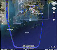
This will be a quick post because I'm almost falling asleep... having bought a new GPS some time ago, I decided that this last week when I was out of town on a service trip, would be a good time to try it. Here's my first attempts:
Part of the travel route that we took, from Huangshi, Hubei (our destination), back to Wuhan, by bus; then from Wuhan to Hong Kong by plane; and finally, by airport express and taxi part of the way to my home.
In case you are interested in how planes circle over Hong Kong before they land, here's a zoomed-up view of the part over HK...
Finally, here's a geotagged album of a walkabout around Huangshi. I still haven't managed to find a way to superimpose the track of our stroll onto the map, but at least the pictures are there...
Will be back with more details later, when I have a chance to recover...
Monday, July 14, 2008
Cool GPS maps
Posted by
tabbycat
at
12:49 AM
![]()
Labels: technology
Subscribe to:
Post Comments (Atom)
1 comment:
Fantastic. I have only dreamed of something like this, but you have done it.
The route from Wuhan to HK confirmed my estimations. Thank you.
Hurry to the eCat.
Post a Comment